Green Infrastructures to mitigate flood risks
in Urban and sub-urban areas and to improve the quality of rainwater discharges

The project recognizes the increased risk of flood events in coastal catchment areas in Sicily and Malta, resulting from the impacts of climate change. This risk has been exacerbated by anthropogenic activities, including the increased urbanization of the low-lying areas of these catchments, creating increased hazards to human life, economic and cultural activities.

The project focuses on the mitigation of these risks, through the increased integration of nature-based solutions in the urbanized sections of these catchments, reducing the flow of rain runoff-water and more importantly giving back water to nature, hence supporting the comprehensive optimization of cross-border coastal communities.

The project plans to develop its mitigation framework through the implementation of three key action areas:

The first action focuses on the testing (adaptation) of three types of GUIs which will be analysed and implemented within the project at laboratory and real scale in Sicily and Malta. The GUIs in question are porous pavements, rain gardens and green roofs, which have been selected in view of their adaptation to the Mediterranean context.

The second action of the project focuses on the integration of these GUIs in a GIS based catchment model which will enable the modelling of runoff flows (and flooding) under different scenarios of GUI application. Two critical urban and sub-urban areas in Sicily and Malta, covering about 70 sq km will be modelled in this GIS-based framework.
This modelling framework will provide a tool through which local and regional authorities can plan the future application of GUIs to mitigate flood risk.

The third action of the project focus on the development of a masterplan which will collate the results of the previous two project actions. It will aim to develop a methodology which will guide local authorities on the establishment of the economically optimal level of the application of GUIs for the mitigation of flood risk.. Agencies can use the masterplan to compare the implementation of GUIs to traditional solutions outside the selected areas taking into account externalities such as environmental, social and economic costs and benefits.

Finally the project will present a policy paper on the application of GUIs to mitigate flood risk, hence providing added focus on the presentation of the project’s technical and scientific results to policy makers. These actions will be complemented by communication and dissemination activities (conferences, green labs, technical visits, expert exchange) carried out during the project which will contribute to the promotion of practical tools integrating the planning and design of GUIs within Low Impact Development in critical urban and suburban areas.

The GIFLUID Project addresses the onset of flooding events arising due to the impacts of climate change and the anthropic urbanization of the coastal landscape, which are two common challenges for the territories of Sicily and Malta. These cross-border territories present similar characteristics namely a semi-arid dry climate a prevalence of high intensity rain events, the historic urbanization of the low-lying areas of coastal catchments.

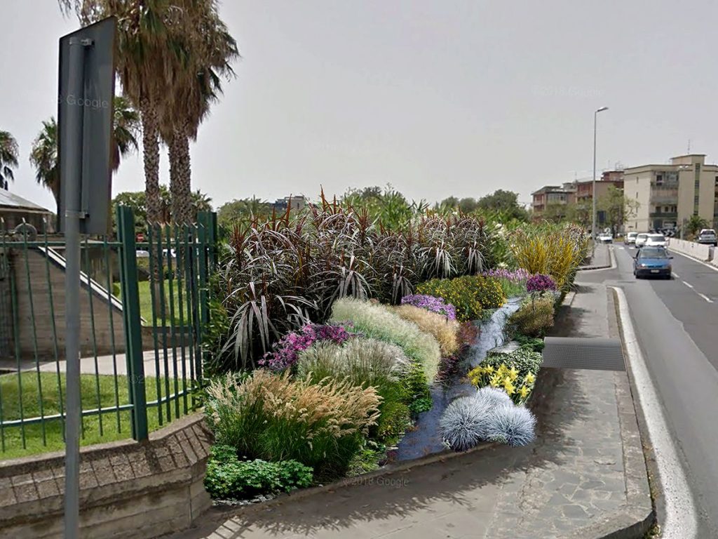
In the context of the admissible action of the IT-MT program, the project aims to develop and promote practical tools which integrate the planning and design of green urban infrastructures (GUIs) in critical urban and sub-urban area of Sicily and Malta, to mitigate floods effects, to increase the infiltration of rainwater drainage improving also its quality (objective).

Results from implemented demonstration GUIs (measures) will be integrated in a GIS-based model which will enable the modelling of runoff flows (and flooding) under different scenarios of GUI application (outputs). A policy paper on the application of GUIs as well as communication and dissemination activities will contribute to the promotion of the capacity building of GUIs in order to increase awareness of policy makers, public authorities/municipalities and other interested stakeholders (beneficiaries).

A masterplan based on a GIS model and including a cost benefit assessment aimed at developing a methodology for the identification of the economically optimal application level of GUIs will be developed for two identified areas (covering 90 sq km). The masterplan will also outline a methodology (tool) which can be used by agencies as blueprints for flood mitigation in similar scenarios (approach).

The adoption of GUIs will also provide an opportunity for addressing a cultural change in the population, by increasing awareness levels of critical hydrological events and how these can be managed (innovation) by adopting environmental sustainable options.

Project duration: 30 months

Start date 01.09.2020
End date 28.02.2023

Programme priority Axis: 3

Protecting the environment and fostering an efficient use of resources

Programme Investment Priority: 5b

Specific objective pertaining to the investment priority: 3.2

To promote systemic actions and technologies able to mitigate the climate change effects and the natural and anthropogenic risks, with a particular reference to the catastrophic from maritime risks
brand
brand
brand
brand
brand
brand
brand
brand
brand
brand